As I closed up my classroom one more time, it began to hit me: I'm leaving first grade. It's time to peel off safety net (that just didn't feel that safe in the beginning) and move up. "I never intended to teach first grade." Those were the words that I kept hearing myself say on Friday to my friends and coworkers. It's true I never wanted to teach first grade until I met Sue Grim and practiced being a teacher in her classroom. Suddenly teaching a kids how to read became the most exciting part of being a teacher. There is not sense of accomplishment that can compete with hearing a kids read and knowing you've had a hand in the process. I will forever think of myself not as a teacher, but a "t-shirt." I adore my first grade team, but I have to confess that this move feels like one step closer to home. So this journey begins a new and I'm really excited about it. My had is bubbling with ideas (I better writing some down), things I want to try, projects I want to embark on. I'll confess, too, that at the back of my mind I'm a little scared that I'll just keep failing...but that's a thought for another post. For today I'm excited to start a new leg of the journey. Interestingly my focus right now appears to be teaching fourth grade, when this move is, at it's core, about moving into administration some day. Hmmm....more to think about, write about on another blog. "All journeys have secret destinations of which the traveler is unaware." (Martin Buber)
Monday, May 27, 2013
Thursday, June 28, 2012
Sunday and Monday, June 24 & 25
(Blogspot is being a little difficult tonight. For the pictures that go with this post, see my Facebook page.)
Sunday, June 24
Finishing the Catlins
There were three stops on our itinerary for the day: Cathedral Cove, Surat Bay and Nugget
Point then head toward Dunedin.
The drive through the Catlins is beautiful! Sometimes we
drove through green valleys, sometimes through winding forests. Sheep dot the hills. If there isn’t a small town a farm caps
a ridge. We’d left the high
mountains behind; these emerald, steep hills were almost as beautiful.
Cathedral cove is an accessible at low tide. We weren’t sure when low tide was (we’d
been out of cell and internet range for at least 24 hors), but we thought we’d
drive in and give it a try. The
entrance was closed off; we went on.
Surat Bay is a sleepy little community of mostly B&Bs
and a few farms. We parked the motor home at a community parking spot (I use
that term loosely; it was mostly just a wide spot not used by the hotel on one
side and the farmer on the other).
Looking out over the bay, there were two
ways to go, on a path through the dunes or across the beach. The tide was out,
there was plenty of sand to walk on, so we picked the beach. In the 1880s a ship
wrecked off this beach; it’s also the home of sea lions. We walked about a quarter of a mile,
then the beach takes a turn and the bay opened before us. We walked another quarter of a mile,
disappointed we didn’t see seal lions.
We walked a bit further towards a tree trunk and a big piece of driftwood. A little closer to the driftwood and it
we started looking a little closer.
When the driftwood took a deep breath and finally moved its flipper, we
realized we’d come across a huge, sleeping sea lion. Satisfied, we headed back. It’s a good thing we did head
back, because as we rounded the cover to finish the last of the beach there was
only about ¼ of the sand left to walk on.
Near the end, I had to head into the rocks to stay above the incoming
surf. Safely back at the car, we headed to our last stop, Nugget Point, which
was supposed to be another good spot for viewing penguins. Yet another
ill-fated stop. The road to nugget
point was 8 km of gravel road riding up and down the face of the cliff. Finally at the car park at 4:45 p.m.,
the lighthouse was a 1 km walk uphill and it’s dark by 5 p.m. One look at the
trail down to the beach and I knew I’d never make it out the door let alone to
the trailhead. I climbed into the
back of the motor home for the return trip and we headed to Balcultha for the
night. (We met the caretakers from Gunn Lake Holiday Park coming off the beach
at Surat Bay. They told us they
hadn’t seen any sea lions.)
We’ve stayed is some really great campgrounds. Mostly gorgeous settings and those that
weren’t had amenities that more than made up for the location. This campground
had neither setting nor amenities, but they did have electricity and
water. In for the night.
Monday, June 25
Dunedin: the
home of Cadbury Chocolate!
Scottish settlers heavily influence the south end of the
south island. Nowhere is that so apparent than Dunedin. We set the i-Site as our destination
and arrived in downtown Dunedin around 12:30 p.m. The center point is
called the octagon. We were immediately wowed by the 19th century
architecture. Our immediate need
included a bathroom and so our that’s where our search started. In a weird twist of events, Jim and I
took two directions with the i-Site as our meeting point (I had to go to the bathroom; Jim
had to pay the parking meter). There was not restroom at the i-Site. The pharmacist next door sent me around
the corner to a multilevel car park.
So I got a quick tour of the area and then met Jim at our original
destination. He picked up a
handful of brochures and we went next door for a soda and some table space to
check out what Dunedin had to offer. The city sits on the Otaga Peninsula and
at the head is a colony of Royal Albatross. There are two roads to get there,
one that drives the rim of the bay and another that goes across the ridge of
the mountains. The GPS picked the
mountain road. I cannot deny the
beauty of what we saw, but ended up spending most of my time in complete and
utter fear. We took the coast road
on the return.
The Royal Albatross Sanctuary is a private reserve that
protects a colony of 24 mating pairs and 18 chicks. Their wing span is 3 meters
(9’ 6”) and their bodies are only about 1 m (3’) long. They’re soaring birds,
using ocean currents breezes to travel. The colder and windier the better for
the albatrosses, according to our guide. We watched a ten-minute video. The most interesting thing we learned
is that they cover half of the southern hemisphere, flying from NZ to South
America to South Africa and back again. The first five to 7 years of their life
is spent flying over the ocean. The ocean is their home during that time. They return to their breeding ground to
mate and raise their chick. A breeding cycle is one year, then the pair goes
off for a year on holiday. The chick fledges in September, no practice, no
flight school, literally fly or die.
From the observatory we saw five chicks. Downy and white,
they sit on their nests for one more month doubling their body size. Their
parents will begin to land further and further away from them, forcing them to
beginning moving and loosing that excess body weight. Soon we saw some adults
soaring above the cliff. They
circle several times then land. We watched one parent feed his chick. Once
finished, the parent flies off again for 1-3 days. Our tour continued with a
the army barracks built into the head.
They had a disappearing gun there, instilled some time during 1886 and
last used in 1949. We headed back
to the car park and spent time watching the sunset behind the lighthouse and
the albatrosses soaring overhead. Back in Dunedin we settled at another Top 10
park. Not as busy, but just as
beautiful.
Tuesday, June 26, 2012
Friday and Saturday, June 22 & 23
Friday, June 22
Te Anau to Invercargill
Just two hours on the road in scenery that we’d spent a lot
of time in. So I read to Jim as he drove.
It didn’t take long to find the Invercargill Top Ten Holiday, but we
decided not to check in, thinking we might drive on. We found the i-Site in the art museum (I’ve learned to use
that word very loosely). We thought
we’d take a ferry to Stuart’s Island, but a little research showed there
wouldn’t be much for us to do and I couldn’t convince Jim that we should rent
motor scooters. To top it all off,
it seems that Invercargill is not the southern-most point of the south island,
so we’re moving on. So over a pot of tea and two tasty desserts (boy do they
make AMAZING cheesecake!), we planned the next couple days. The ONLY bad thing about the
campgrounds we’ve been staying in is the cost of doing laundry. We thought we’d
be smart since we had a lot of extra dirty things—sheets and towels this
time—so we asked at the i-Site for a Laundromat. They directed us to the only one in town. First it was hidden in the back of a
dodgy strip mall, there was no sign marking it, and it looked like we had
stepped into an establishment in Mexico!
Back to the campground we went, filling their washers and sitting
outside with them, reading (Jim) and writing (me). The campground is beautiful! The buildings are brick; the
sites are large with trees and flowers all around. We’re parked right next to the kitchen/showers/laundry, a
cute little block building surrounded by flowers. We sat on the porch, drinking
tea and waiting for the laundry. Fifteen-foot
high hedges surround homes and property.
Thy look like yew bushes allowed growing to about nine or ten feet tall
and then trimmed perfectly straight, forming an impenetrable hedge around the
property. I had a great visit with
the owner tonight and she said they have a tractor with a large army that comes
in to trim them. It seemed like the most natural thing in the world to her.
(Had a nice visit with her about her daughter, the teacher in England.)
Invercargill isn't much to write home about--at least not the areas we found. They have a historic walk around the town and a have a history of shipping and shipwrecks, but nothing really sparked our imagination. We feel like time is beginning to run short and there's so much more to see!
One can stew, books, and turning in early. Tomorrow we head
to the Catlins.
Saturday, June 23
The Catlins
The southern most stretch of coast is called the Catlins. It’s probably only about 136 km long,
but there are tons of cool things to do and see. We left Invercargill around 10:15 a.m., heading east. This
scenery is lest dramatic, but more like the very north: rolling green hills, long stands of
trees, tiny patches of trees and in other places trees forced at a 45 degree
angle from their trunk by extreme wind.
The Foveaux Straights is to our right, rain clouds chasing behind us.
Our first stop was Waipapa Point, the sight of one of the
worst shipwrecks in NZ history. In
1881, 131 out of 151 passengers and crew were killed. A lighthouse was eructed at the dangerous point. But even cooler were the five sea lions
and one fur seal we saw playing on the beach! Like the other beach we’ve seen, there are volcanic rocks
that make up parts of the beach.
Sometimes the wild life is hidden among them. These guys were not hidden! Three sea lions and a fur seal converged on the beach and
began playing—of course it looked more like fighting, but no one was killed as
a result. A bit later an even
BIGGER sea lion joined the band of pranksters and showed them who was the
boss! We watched them for 30
minutes, and then started exploring the rocky beach we were on. We were careful
not to step in the pools of standing water, but even we walked away a little
damp. We walked around the
lighthouse and then headed back the motor home for lunch. As we ate the rain
hit.


Our next stop was Slope Point, the southern-most point on
the south island. Slope Point is on cliff about 40 feet above the surf. A small electronic lighthouse marks the
point and a sign gives the mileage to the equator and the South Pole. However the sight is entirely on
private land. The trail is a fence
line. We sat in the motor home and
walked ugly rain clouds roll in off the ocean, but there was some blue sky
too. Taking the chance that the
blue sky would win, we headed out with our cameras. The wind pushed against us, trying to keep us from our
goal. Once there we were cold and
quickly started getting wet: the rain clouds won! Our tramp back to the motor
home was faster than the downhill trek to get to Slope Point. We warmed up with a cup of hot tea. The wind was blowing so hard, there was a draft around the refrigerator. Had we stayed much longer, we would have had to move the motor home to put the back to the wind.


Our next stop was Curio Bay for penguins and more sea
lions. On the way there, we were
sidetracked by a sine for a petrified forest revealed on the beach. Not sure what we were going to see, we
headed down to the rock terraced beach and saw, standing on a rock above the
ocean, a yellow-eyed penguin. He
must have been two feet tall with yellow feathers around his eyes. It was not
hard to see his white belly against the black volcanic rock. We waited a little longer and started
seeing more up around the bush line taking shelter for the night. Soon we watched two more come up on to
the beach. Soon the old man out on
the rock started to head in for the night. We figured that his tribe was in for the night. On the return walk to leave the beach,
we realized we were walking on the petrified wood as part of the beach.


We saw a campground as we turned to go to the Petrified
Forest, so we headed in there.
It’s a Department of Conservation Camp, some sites have electric, it
costs $2 to start the showers and there are toilets. You drop some money in an honesty box to camp here. It’s an amazing spot, just east of the
beach where we saw the penguins…we could walk back to that beach in minutes!
However, we got ourselves stuck here.
Jim tried valiantly to get us out to no avail. We did stop to pray first
and I’m really glad we did. He
walked to another campsite and two little woman walked back with him to help
push us out. With a their help and the blessing of God we got out of muddy
mess! We’re safely tucked away in a spot where the tall plants protect us from
the strong winds. The temperature
at 6:30 p.m. was 6 degrees C. I think with all the adventure we’ll sleep well
tonight!
We may not have made it very far, but what we saw was
amazing!
Monday, June 25, 2012
Wednesday & Thursday, June 20 & 21
Wednesday, June 19
Haast to Te Anau
We weren’t impressed with Haast when we saw it in the
daylight. The land is primarily flat, no ocean within sight and mountains to
the south. But like most drives
here, we quickly entered dramatic countryside that kept our full attention. The
valley are obviously formed by glaciers, the bottoms rounded riverbeds that are
lined with gravel and rocks. The valley floor is washed with grey-blue glacier
water. Valleys cleave mountain ranges; clouds hang low in them. Frost paints the grass on the shaded
shoulder white and shimmery. These mountain peaks are frosted white and I
wonder if it melts away in the summer, or forms a permanent tam for the peaks.
Right now the header reads “Haast to _________,” a typical
title for this half of the trip.
We have three or four more things we’d like to see and know we’ve got
ten more days to see them. We pick a point on the map, usually a bit farther
than we typically go, enter it into the GPS and just drive. We stop to look at
waterfall or investigate a coffee shop or eat lunch, or nap, depending on the
day.
The unrelenting beauty continued. The climb to Haast Pass was through a glacier valley. We stopped for a little walk to
roadside waterfall and nearly got blown off the road and turned into
tourist-cicles. The
temperature was dropping quickly—it’s about 5 degrees C.


The road crossed over a roaring glacier
melt river, running over huge boulders and descending rapidly. The grey-blue color of the water, the
grey of the rocks, and the speed of the current all combined to force Jim to
turn around and pass the river again.
In a very un-Kim like move, I asked Jim to stop of the one lane bridge
so we could get some pictures. If
you know me, you’ll know why that was amazing!

We climbed, but trees and clouds hemmed us in. The temperature dropped more and our
first sighting of snow came. At
top of the pass the valley opened into grazing land and the snow looked to be
six or seven inches deep, maybe a first or second snow for this area. A little fuel and a little lunch helped
us down the road and we watched as the temperature continued to drop to 2
degrees C. Just as suddenly as we came upon snow, it disappeared like we had
crossed over the imaginary line.

There are two lovely lakes within 1000 meters of each other,
both formed by glaciers and filled with glacial water. As we drove and drove and drove and
drove to get past the first, we couldn’t believe that this lake didn’t beat
Lake Taupo as the biggest lake. (Same thing goes for the beautiful lake outside
Queenstown.)
The tourism radio has been fun to follow. Once in a while we get some good advice
on a place to check out. Today it
was the Cheeky Monkey in Waneka. How can you not fall in love with a teashop
called the Cheeky Monkey? We stopped for tea and sweets; the tea was strong
black tea served in a silver pot.
It was accompanied by a pewter pitcher of more hot water, as the tea was
so strong it was good for another pot. A yummy slice of brownie with sweetened
condensed milk and chocolate and a chocolate Turkish biscuit (cookie) rounded
off this sweet stop.


We climbed
again, this time through more scrub-like growth covering the mountains. As we came around the last curve before
the descending, the world opened up to a green, lush valley way, way, way, way,
way below. This pass was going to
be a problem. I kept my head down
and read while Jim expertly got us off the mountain, kindly not speaking so
that I thought he was fully concentrating on the drive.
The trip into Queenstown from there was quick. Queenstown sits on a huge lake, the
color of which is hard to describe.
It’s grayish-turquoise with a hint of purple (I know Amy Moser will know
this color immediately if I ask her). Even that description seems
inadequate. On our side the
highway road up and down the mountain.
On the other side the mountains dipped their toes into the lake.
We’re settled now in Te Anau, dinner done and bed
calling. Tomorrow we cruise
Milford Sound.
Random Thoughts:
·
Why in the world does this country only have one
way bridges?!
·
There are tons of elk farms on the south island.
·
Cheeky Monkey—say it three times and you’ll
smile for 30 minutes.
Thursday, June 21
Milford (Fiord) Sound
Another great tour day. There has got to be something said about sitting back,
enjoying the scenery and letting someone else drive. Ray of Milford Adventures picked us up at 8:30 a.m. We’d been enjoying visiting with the lady
behind the desk at Te Anau Top Ten.
She showed us live pictures of Milford and said that, even though it was
cloudy and dreary in Te Anau, it would be a beautiful day on the water.
Our host and driver was Ray who looked to be in his early
70s, enjoying a part time job as a tour guide. Later that day we discovered that he was probably around
Mom’s age and that this was his personal business. Ray was full of great information as we traveled to
Fiordlands National Park and it seemed that he knew everyone. We stopped at the park office, which
was vacant but for one elderly lady watching the property for the winter. Ray took her a bundle of kindling for
her fire; in exchange she brought him 20 kilos of chocolate from the Cadburry
factory in Dunedin. At our first hiking stop to see a beautiful waterfall, a
Conservation Department crew was working on the trail. We hiked a hard five minutes up the
trail to the cascade but only after Ray had greeted each worker by named,
hugging the ladies and slapping the backs of the men.
The first stop was just past the entrance to Fiordlands
Nation Park.

The field was dreary
winter brown, but the mountains, the Southern Alps, were grand, with a healthy
dusting of snow at the tree line and heavy snow on the peaks. I didn’t wanted to walk into the field
because I thought a fiord was a swampy wetland with fingers of ocean (like
Milford Sound) carving into it.
Ray explained that a fiord is a u-shaped valley carved by a glacier and
backfilled by ocean. There was no
ocean to be seen—I was safe. But the mountains were truly magnificent to
behold. We would spend the day
driving below them in the u-shaped (unfilled by ocean) glacial valleys with
streams, waterfalls and rivers running through them. I’ve tried all day to put
into words the grandeur of what we were seeing and experiencing. I am at a loss. Ray kindly offered to
take our picture at every stop.
I’m sure he does that for all guests, but he particularly liked Jim’s
camera and since we were his only passengers for the day, he took many great
pictures of the two of us.
Briefly after this stop, Ray pointed out a small sign that
said “Latitude 45 degrees south.”
We were passing the point we were equidistant from the equator and the
south pole. We moved on to Mirror Lakes, small oxbow lakes that functioned as
accurately as their name.

Knobs Flat was a restroom brake. At the next stop he walked us up to the
Cascades, beautiful tumbling water flowing from the mountain.

Lake Gunn as still shrouded in mist,
but we enjoyed a fast stop there for another picture. From there We went into
the Hollyford Valley and stopped at the Hollyford Camp. During the initial 10
years of construction on the road to Milford Sound, it served as a camp for the
workers. In later years it was turned into a holiday park. We stopped there for tea and muffins
Ray and the care-takers. The
community kitchen already had a fire in the fireplace so it was a cozy place to
sit and visit.
From there we stopped at the Chasms, a 5 minute return
hike. The water coming off the
mountain has hammered huge round holes in the granite rocks. Amazing! Next stop the tunnel that burrows through the mountain,
connecting east and west. The
original surveyor said that it would be the cheapest way to Milford Sound and
would only be about 35 meters…I think Ray said that it was close to 2,000
meters long. The single-lane road is controlled by a traffic light in the
summer. During the winter good driving controls traffic! Through the other side, we stopped for
another breathtaking view and descended toward Milford Sound.
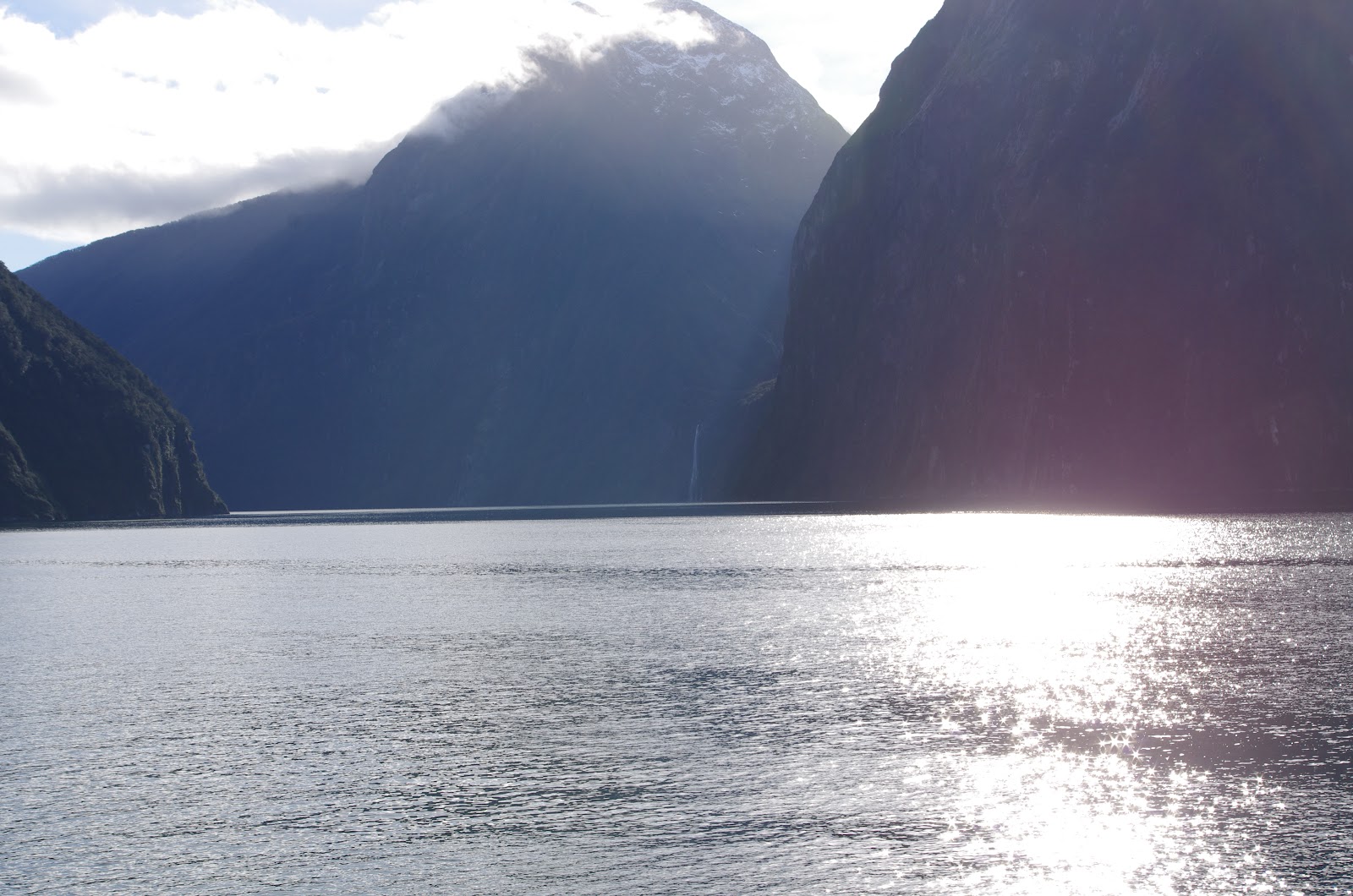
Once we arrived at Milford Sound we immediately boarded our
ship. Jim and I found a seat on
the upper deck in the sun and ate our lunch. Peanut butter and jelly always tastes better outside! The cruise got underway about 15
minutes later, traveling around the walls of the fiord. There are beautiful waterfalls all
around. Miter Peak is the highest
point in the sound; I think its in about every picture I’ve ever seen of
Milford Sound. The tour even went out onto the Tasman Sea to view St. Ann’s
point and the lighthouse there.
Down the other side of we stopped to view a group of young male fur
seals playing in the water. It was
a beautiful and COLD afternoon! I had to go inside for a cup of tea just to
warm my hands.


The return trip was faster, no stops, a little visiting and
back at Te Anau.
Thursday, June 21, 2012
Monday and Tuesday, June 18 & 19
Monday, June 18
Greymouth to Franz Joseph
Overcast, the mountains socked in, we decided to head south
and try the train trip at the end of our stay. A weather report on Yahoo sends us south a little faster, as
there is a front moving north east that could cause flooding and snow in the
high country, ending in Auckland.
We may loose it in our southerly directions; regardless it seemed to
follow us all day.


The road took a turn away from the ocean and into the
forest. Here giant ferns line the
forest floor and tall skinny pines block out the sky. The roads become winding through here, narrowing and
climbing.
We arrived in Franz Joseph, the site of the Franz Joseph
Glacier around 3:30 p.m. Our first stop was the iSite to book a helicopter
ride. The employee there said
she’d book the flight for us, but we probably wouldn’t see anything with the
low-lying clouds. Checking the
weather forecast, she didn’t hold out much hope for tomorrow, either. So we checked into the campground, then
explored Franz Joseph a little.
Jim headed towards the glacier and in just a few minutes we arrived at the
carpark from where most of the trails take depart. We could see small glimpses
of the glacier, like a white, icy finger draped over the side of the
mountain. There is one trail that
takes hikers within a couple miles of it; we’ll try it tomorrow.
Back at the campground, I tried to make a meat loaf. Should be simple, but the finished
product left a lot to be desired to make it a “comfort food.” Mostly it was the
NZ ketchup that I put across the top. I should have tasted it before smothering
the whole meatloaf in it. Sweeter
than ours, with an unknown, UNWANTED spice added. No more NZ ketchup!
The camp has a spa. We made
a reservation to soak at 7:30 p.m.
On the way there, a lovely older couple followed us in and thought
they’d be spending the time with us.
Our host quickly told them you had to make a reservation and they could
have the half hour following us.
We spent a relaxing half hour soaking and headed back the motorhome for
the night.
But the story doesn’t end there. At 4:30 a.m., Jim’s phone
rang. He answered a call from
Kaitlyn and all he could hear was crying and sniffling, then the phone hung
up. We both jumped up, immediately
awake and dread-filled. Neither
phone had signal, so in record time we were both dressed, Jim unhooked the camper
and we took off looking for cell-phone signal, praying the whole time. Less than one kilometer toward town, my
call to Kaitlyn went through. She
was on her way to work, happy as a lark, completely unaware that she had
butt-called us. Relieved we went
back to camp and slept the rest of the night.
Tuesday, June 19
Flying Over the Glaciers
I’ll put it in perspective this way: between the two of us, we took 410
pictures today!
When I woke up 3 hours after our 4:30 a.m. run into Franz
Josef and looked out the vent window, I really thought we’d have to settle on a
hike to the snout of the Franz Josef Glacier. Jim was so convinced that we’d hike instead of fly that he
was making our lunch for the trail: peanut butter and jelly sandwiches, fruit,
cookies and water. In a quiet moment, we heard a helicopter fly over. Ten or fifteen minutes later another
flew over the camp ground. Then we
headed to the showers and realized that it was sunny, the mountains were clear,
and there just might be a chance we’d be flying after all.
Jim made a reservation for us and a staff member from the
holiday park took us into the village of Franz Josef to Glacier Country
Heliport. They put us on a little later flight, so we went across the street
and did a little souvenir shopping.
We didn’t have long though.
They sent an employee over to tell us check in would be early. I am very
afraid of heights. I am not afraid of flying. I didn’t think I’d be afraid of flying in a helicopter.
However, there was that moment when the nose tipped down, the tail lifted and I
realized that we were going to fly quite high in the air with not around
us. I squeezed Jim’s hand, closed
my eyes for 10 seconds and opened them quickly, afraid I’d miss something. From the next 30 minutes I had the
biggest grin on my face! To
protect your ears from the noise of the helicopter and hear the pilot, we had
on earphones but no microphones for us.
I think it’s because the pilot would get really sick of hearing people
like me yelling, “THIS IS SOOOOOO COOOL!”
We went over the town and gained altitude. When we arrive at the Franz Joseph Glacier (FJG), we were
already quite high in the air. We
descended the glacier in an S pattern.
I know the pilot told us cool facts about the glacier, but I just kept
thinking, “This is the coolest thing IN THE WORLD!” He set the helicopter down on the ice and two of our
passengers met their hiking group.
Claire and Will would spend the day descending the glacier, their last
hurrah before returning to the UK after four years in Wellington (he is an
audiologist…I could keep going).
The pilot went to the Neve (head) of FJG and left skid marks in the snow. He told us why he was doing it, but I
just kept thinking, “This is AMAZING!”
From there we flew over the Victoria and Cook Glaciers (there are 140
glaciers in 200 sq. km) and then we flew to the Neve of Fox Glacier (FG). Here the pilot spent some time making
skid marks in the snow and finally setting down the helicopter. Before we landed, I looked up to the
peaks and across the snow field and just praised God for this unimaginable
beauty. We sunk to the step above the skids. He went off and stamped down snow so we could walk out onto
the glacier. It was cool to see
that just 2 or 3 inches below the top layer of snow was the mysterious blue of
glacier snow. I got out first, took three steps and sank to my butt in glacier
snow. I kept waiting for Jim to come get me out…he was busy laughing and taking
pictures of me sunk to my butt in glacier snow. The pilot went ahead of me and stamped more snow. He said, “That should be good for
you.” I laughed as I was still hip
deep in snow and called him a liar.
He laughed back and said, “It isn’t gonna hurt you.” He was right, I pulled out of the
whole, took two more steps and sank again! But revenge is sweet and Jim sank
too! The pilot took our picture, both with his camera (we bought that picture
for $200—what a racket!) and with mine. The peaks above us were the Tasman
Peaks. Above that was Cook’s peak,
but wasn’t visible in the picture. Back in the helicopter and in the air, we
toured the snow field we’d landed in, flew over the peaks and around the
mountain to look for wild life. A
heard of Himalayan Mountain Goats was released here (he said when, but all I
could think was…well, you know). Sure enough, he scared a herd that began the
unimaginable run down the vertical
mountain face. The pilot pointed
out the alpha goat. He was easy to
find: he went face to face with
the helicopter. I thought he’d
jump off the mountain to challenge the helicopter! We saw Fox Village, the snow of the glaciers opening to the
valley below and the sea beyond.
Within minutes we set down on the landing pad. The pilot graciously
answered questions: all I could
think to ask was where he got his training. He assured me that flying these mountains takes a lot of
skill. Jim talked helicopters with
him and I just kept thinking, “This is the COOLING thing we’ve done so far!”


Another gift shop called my name and we spent ten more
minutes shopping. Across the street we stopped into a coffee shop for
lunch…best lunch in NZ to date but the coffee isn’t getting any better. Our
driver from the Holiday Park offered to pick us up when we were done, but we
decided to walk off our lunch. I
never regretted that decision. The
day was cool in the shade, pleasant in the sun. We got a close look at the
sub-alpine rainforest of the area and it just felt good to walk.
Looking at the map we planned to go about 280 km to
Cromwell, NZ. Just a few km down
the road was Fox. They had a cute
little coffee shop at the iSite.
However I think I’ve learned my coffee lesson: we ordered a pot of tea and a scone to share. Back on the road Jim decided to drive
to the carpark at the base of the Fox Glacier. It was a lovely drive through
the rainforest and beside the glacier river coming off Fox. Signs in the
carpark said that we could get within 200 m of the snout. The trail looked pretty level, mostly
through the riverbed, so we started walking. We walked all the way to the view area 200 m from the snout!
We didn’t expect to, it just kind of happened, but we’re so glad we did! The
snout had to be between 20 – 40 meters high, we really couldn’t tell. We
remembered that this glacier is advancing 4 meters/day. We felt triumphant on the hike back—we
stood on the head of this glacier and walked to the base of it! There were two signs on the way into
the carpark. About halfway from
the main road was a sign that said, “The end of the glacier in 1750.” Half way between that sign and the
parking lot was another that said, “The end of the glacier in 1850.” It was hard to believe that it had
receded that much in such a short time.
About halfway down the trail we saw three groups up on the glacier. At the view area, we watched the first
group walk down the final few meters to the trail. We also saw a couple on the
trail who were on the White Island Tour.


We left Fox at 5 p.m. with the sunset to our right. We weren’t going to make it to Cromwell
and settled on Haast, 86 km away.
Good thing we “settled.”
Within a few minutes of climbing away from the ocean and back into the
mountains, the temperature dropped 2 degrees C and frost was already forming on
the shoulders. Jim slowed down out of respect for black ice. We had a tough time finding the holiday
park. We turned down a road with a
service sign for gas, food, camping and motor homes. Fourteen km later we turned around and went back to the main
road. Not 2 km later we found the
Top 10 Holiday Park right on the highway!
Despite the Asian driver that tried to scrape the front of the motor
home with his rental car, we’re settled for the night. Tomorrow: Milford Sound?
Best day to date!
Jim’s Random Thoughts:
·
Kim was grinning from ear to ear in the
helicopter.
·
Standing at the head of the glacier was
phenomenal. Seeing the blue ice
below our feet was amazing!
·
The agility of the goats charging down the
mountain…WOW!
·
The glacier ends in a rain forest!
Saturday, June 15 and Sunday, June 16
Saturday, June 15
The Cook Straight
Alarms were set for a 5:30 a.m. wakeup for our 7:15 a.m.
arrival at the Interisland ferry from.
One of the few times I’ve ever seen Jim nervous, I couldn’t tell if he
was nervous over a new experience or nervous from the excitement of the
crossing.
We didn’t believe the lady at the holiday park. She said it would only take 15 minutes
to get to the port. We’d gone by
there on the bus and it took a lot longer. Good thing she was right because we left late but arrived
with no problems. Jim was still
excited and nervous. Reflecting on
the day I think it was because he was excited to be on the ship. It was HUGE.


Jim drove the motor home up into the belly of the beast, we secured
everything and then went up to the passenger decks. I was surprised at how nice the ship was. There was an aft two story observation
deck (just outside the bar where singles and families alike camped out on the
cushy couches and chairs), an indoor reclining (chair) area with a couple
different cafes to choose from. On
the second deck there were two movie theaters (that you could pay to watch
movies in), there was an iSite to get info about Picton where we would land and
even a trucker’s lounge. Jim and I ate breakfast while the ship was still in
the bay and then I wanted to explore…that didn’t not last after the ship got
underway. Jim thought the
observation deck would be a good place to sit, there was a lot of fresh air and
it wasn’t as much motion back there.


I could tell he wanted to go outside, but I finally got the point where
I just wanted to lay down and pray for deliverance from the sea. We settled in
the comfy chairs at the front of the ship. I slept curled in a chair and Jim read. About 40 minutes out of Picton on the
South Island, I woke up feeling better.
Scones and tea settled my stomach (and a bite of some exceptional
cheesecake). Now that the ship was
calm, I was ready to go outside and look at the sound. Picturesque, tranquil, isolated,
perfect. According to Jim the
perfect place to live is on the ocean with a mountain rising behind your
house. We found that place. The homes lining little coves went form
simple to enormous. Many must have
generators, as no power lines were visible. Access appears to be by boat through the sound. Already the south island was looking
more dramatic and rugged.


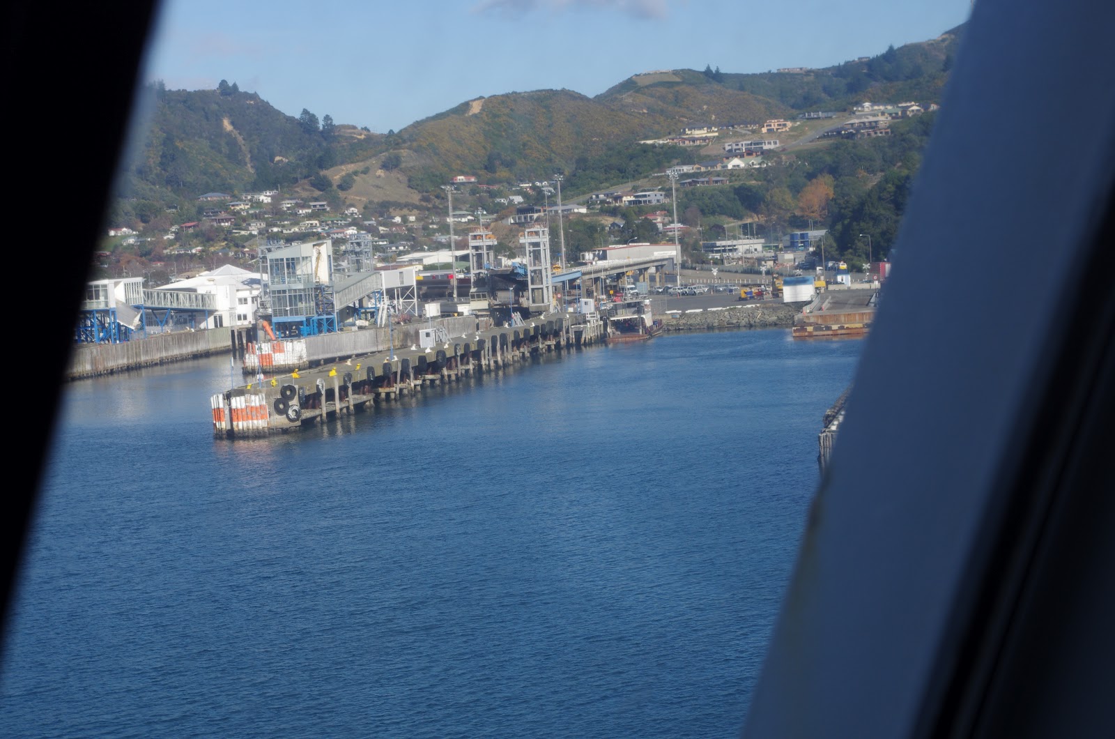
As soon as we landed we took off for…we weren’t sure. Greymouth was at the back of our minds.
Regardless of the destination, the journey was well worth it. The road took us through wine
country. Vineyards lined the roads
and rugged high mountains provided the backdrop. The road went south and then traversed the width of the
island. Mountains began to line both sides of the road. Elk farms popped up (we only saw one on
the north island). Jim spotted
them by the five or six foot elk-tight fences.
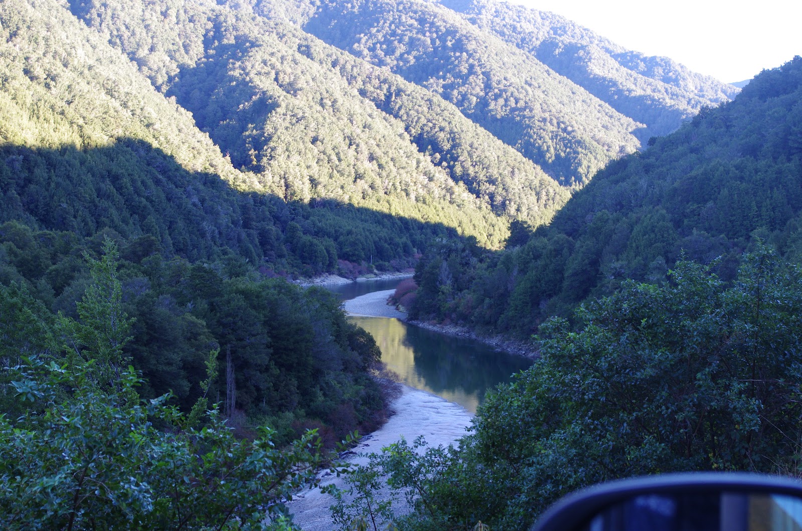
On the last leg of our journey, the road took us through
another scenic valley. A river lay
at the bottom of the valley through which we drove. We were a good 50 – 70 feet above it and often in the
trees. Glimpses of the clear water
were like photographs from travel magazines. The road slowed here, but it was
well worth it. The drops were often
shear, but hidden by the tall sentinel trees that grew up sides of the
mountains.

We finally decided to head a little north to Westport. This little town was a center of coal
production. We weren’t excited
about visiting, but it seemed like a great point to pick up the coast road that
will take us south.
A fast visit to the beach was a great idea. The sun was
setting on this long, smooth stretch of black and white sand. Back across the road we camped for the
night, doing laundry and cooking dinner.
I hate to see the second week draw to an end.


Sunday, June 16
Westport to Greymouth
Happy Father’s Day!
We woke up cold for the first time and came to adore the duvet on the
bed. It was hard for Jim to get out of bed and switch the propane tanks so we
could have heat and hot water for tea.
The day broke grey, but that hasn’t affected the beauty of what we’ve seeen. We’ve begun the drive down the west
coast of the south island. From
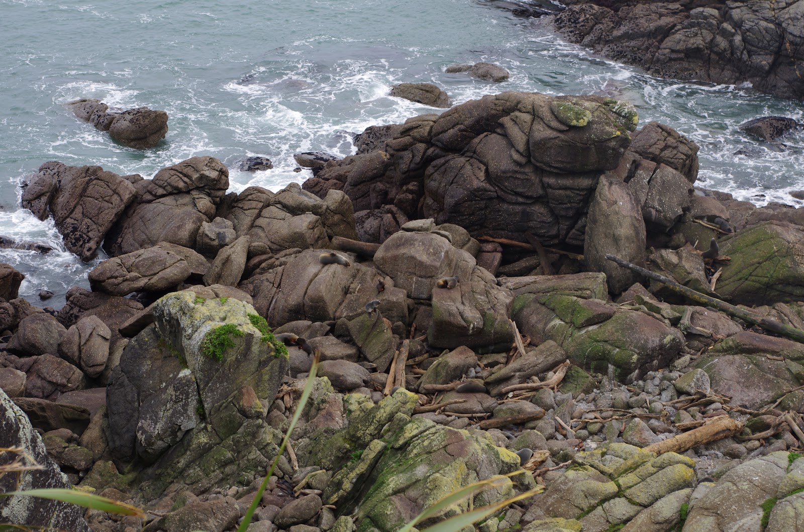
our campground in Westport, we headed south to Cape Foulwind and the Seal
Colony. What a great side trip! We
parked and hiked an easy 500 km uphill to a lookout over the seal grounds. A formation of volcanic hills growing
from the sea form a protective, rocky home for a colony of about 20 seals that
we could see. At first we saw
three in a protective cove. Coming
around the trail further we got a full look at the rocky point they call
home. Among ten to twelve adult
fur seals, there was at least the same number of pups. It was fun to watch them
navigate the rocks from the small pools back to their colony. They cried and called to one another
and the adult seals seemed unaffected by the play and seeming distress of the
pups. This point is a good place
for them because there are small pools in which baby seals can play. I probably watched them for 30 minutes;
Jim finally had to drag me away so that others could step up to the rail and
take a look. I was amazed that one
woman walked away complaining that she couldn’t see any seals. We hiked on up the cliff for about 500
more kilometers until the trail crossed over a fence. Looks like it would be a GREAT trail, terminating around the
Westport lighthouse. Back at the
motor home we made lunch—hot soup and warm bread.

The road took us inland just a bit. We spent twenty minutes driving through
farm country, staring at the snow-capped mountains, and searching for elk farms
(which we found!). Soon the road
turned south again and we found our selves driving along the volcanic coastline
once again. Just about the time I
couldn’t stand the height any longer, Jim pulled off and we spent a little time
taking pictures of the pancake rocks and blow holes around Paikuku
reserve. Although the road crested
on a bluff, it quickly dropped back down to sea level. The road reminded me of PCH in
California, but this one was a bit easier for me to take. Every turn revealed more beautiful lava
coastline. House were scattered at
brief intervals up and down the coast on both sides of the road. Some were fancy, others practical. Some
had smoke roiling out of a chimney, others looke desolate. As we got closer to Greymouth farmland
separated us from the Tasman Sea.
We could see pasture and crops like a patchwork quilt between the road
and the ocean. There were more elk
farms in this area. We spot them
because of the five-foot fence.
We got into Greymouth around 4 p.m. It just started drizzline as we ran
into the grocery store (which was beside the Greymouth TransAlpine
station). The drizzle chased us to
the campground. As I sit hear
typing, rain blow and dancing across the roof of the motohome. We are snug
inside, well fed and warm.
A side note:
our campground hostess says that we won’t see much on the TransAlpine
Train if the day isn’t clear. The
weather reports for both Greymouth and Christchurch is rainy for the next five
days. Looks like we’ll head south
to the glaciers tomorrow.
Random Thoughts:
·
None of the elk on the elk farms have antlers.
The herds are big…bigger than I’ve ever seen.
·
The Tasmin Sea is the same color as the
Caribbean when I saw it at Tulum after a storm—a grey-blue. Further out it’s dark.
·
Seal pups are loud!
·
I am constantly looking for seals now that I’ve
seen them at Sea Beach. Maybe a
whale next.
·
The third Sunday of June is NOT Father’s Day in
New Zealand.
Subscribe to:
Posts (Atom)